Versão em Português
Project

Socioenvironmental Management in Municipalities of Pará

Institute of People and the Environment of the Amazon (Imazon)

Project official website
Total project value
R$ 9,736,473.00
Total support amount
US$ 5,173,746.21
Concluded

Presentation

Objective

To mobilize state and municipal governments, rural producers, unions and associations, aimed at: speeding up adherence to the Rural Environmental Registration (CAR); monitoring deforestation using satellite images; and helping plan landscaping as well as restoring degraded areas in the Uraim River Basin, in the municipality of Paragominas

Beneficiary

Total population in 11 municipalities – 482,000 inhabitants, according to the 2008 Census conducted by the Brazilian Institute of Geography and Statistics (IBGE)

Territorial scope

11 municipalities in the state of Pará

Description

CONTEXTUALIZATION

Brazil’s state of Pará has one of the highest deforestation rates, according to 2014 data from the National Institute for Space Research (INPE). Pará has the fifth largest cattle herd in the country, with about 17 million head of cattle.
The agricultural products highlighted are rice, beans, corn and soybean, in accordance with the 2009 Census conducted by the Brazilian Institute of Geography and Statistics (IBGE).

Municipalities included in this project belong mainly to the Southeastern Pará meso-region, namely: Abel Figueiredo, Bom Jesus do Tocantins, Moju, Dom Eliseu, Goianésia do Pará, Itupiranga, Jacundá, Paragominas, Rondon do Pará, Tailândia and Ulianópolis.

It is important to mention that, at the beginning of the project, the Ministry of the Environment listed six of the 11 municipalities as municipalities needing priority efforts to control and monitor deforestation in the Amazon (the municipality of Paragominas was removed from the list before the beginning of the project).

THE PROJECT 

The main aim of the project Socio-Environmental Management in Municipalities of Pará State was to help reduce deforestation and the degradation of the forest in the 11 municipalities the project covers by mobilizing local players – the state and municipal governments, rural producers, associations, unions etc. – and to collect environmental and land data on rural properties. The project also sought to help land regularization, encouraging agricultural producers to adhere to the Rural Environmental Registration (CAR) in a more timely fashion.

During the project, the Deforestation Alert System (SAD), developed by IMAZON, was used to monitor deforestation in these municipalities and to guide the supporting efforts to oversee and reduce deforestation.

The project also included mapping the permanent preservation areas (APP) in the 11 municipalities and a diagnosis to implement reforestation in the APPs in the basin of Uraim River, in Paragominas.

INTERVENTION LOGIC 

The project falls within the "Monitoring and Control", "Land-use Planning" and "Sustainable Production"components of the Amazon Fund's Logical Framework.

Click on the following image to view its objectives tree, that is, how the project's outputs are linked to the expected outcomes and impacts.

quadrologico_EN

Evolution

Date of approval 12.01.2009
Date of the contract 07.29.2010
Date of conclusion 09.30.2014
Disbursement period 48 months (from the date the contract was signed)
approval
12.01.2009
award
07.29.2010
conclusion
09.30.2014

Disbursement

date amount
1º disbursements 01.28.2011 R$747,061.33
2º disbursements 09.19.2011 R$2,829,395.03
3º disbursements 02.24.2012 R$1,499,887.07
4º disbursements 09.10.2012 R$1,499,887.06
5º disbursements 09.25.2013 R$1,738,133.38
6º disbursements 03.27.2014 R$1,422,109.13
Total amount disbursed R$9,736,473.00

Total amount disbursed in relation to the Amazon Fund’s support

100%

ACTIVITIES CONDUCTED

The main activities carried out within the scope of the project can be summarized into nine topics, namely:

  1. Local pacts to reduce deforestation in municipalities
    Support to prepare to formalize ten municipal pacts to reduce deforestation by coordinating with key players, collecting information and revising agreements. The main commitments included in the documents are, among others: (i) to maintain annual municipal deforestation below 40 km²; (ii) to implement the CAR in at least 80% of the registable area within the municipality; and (iii) to check deforestation in the field when receiving an alert. IMAZON established a routine to transmit information to municipalities concerning how deforestation and the CAR have evolved so as to help fulfil the pacts signed. Before the project began, the municipality of Paragominas had already signed the pact.

  2. Environmental monitoring and inspection on a municipal scale
    Forwarding 229 monthly bulletins on deforestation alerts to local and regional authorities responsible for environmental management in the 11 municipalities of the project, aiming to improve the monitoring processes, environmental control and responsibility in these municipalities.

    Throughout the project, it was noted that municipalities, when receiving deforestation alerts, raised insufficient information to issue a notice of violation through the Pará State Environmental Department (SEMA-PA). To overcome this problem, the SEMA-PA elaborated a specific report model for this purpose, and the IMAZON organized training to prepare the reports for some municipalities.

  3. Local training sessions on geo-processing and remote sensing
    Sixty-two technicians and 12 representatives from local associations in geo-technology applied to environmental management received training. The training addresses, among others subjects: (i) collaboratively monitoring deforestation; (ii) geo-technology applied to the CAR; and (iii) environmental legislation and inspection.

  4. Preparing the digital mapping base
    Mapping bases in the scale of 1:50,000 were prepared in 10 municipalities the project covers, together with technical guidelines concerning how the instrument is to be applied to the operational routines in the municipal environmental departments. The municipality of Paragominas already had a mapping base.

  5. Participatory land mapping
    A method was developed, validated and applied to implement participatory land mapping in the municipalities of Tailândia, Paragominas and Moju. This methodology is being disclosed in different forums that bring together experts on the subject of land regularization, such as: the Technical Assistance and Rural Extension Company (EMATER), the National Institute for Colonization and Agrarian Reform (INCRA) etc. The methodology has the perspectives of growing and to be used in several other cities.

  6. Assessing the signature and fulfilment of terms for conduct
    change (TACs) for environmental regularization of rural properties A study was conducted to assess the situation of 42 TACs aimed at restoring environmental damage in rural properties in Para State, by checking content, rules and procedures for signing and monitoring it. As result of the study, SEMA-PA published the Normative Instruction
    Nº. 14/2011, via which it assigned a responsible sector to effectively monitor the terms. Additionally, the IMAZON assisted the SEMA-PA and the Federal Public Prosecutor (MPF) in developing a method to audit TAC implementation for livestock in the state of Pará.

  7. Evaluating and monitoring efforts for land regularization promoted by the federal and state governments
    The efforts in the Legal Land Programme, in the federal sphere, and those made by the Institute of Pará Land (ITERPA), in the state sphere, were monitored. In addition, the pending land issues in the state of Pará were mapped. These efforts helped prepare a legal framework that prioritizes efforts towards land regularization in municipalities that reach the goals of the Green Municipalities Programme (State Decree Nº. 739/2013).

  8. Landscape planning and forest restoration
    Initially, this effort envisaged landscape planning activities only in the Basin of the Uraim River, in the municipality of Paragominas, having been expanded to the 11 municipalities of the project.

    APPs mapping was conducted in 11 municipalities, covering 445,000 hectares of APPs, some 54% of which is deforested. For each municipality, a map showing the situation of APPs soil coverage was prepared.

    Additionally, a diagnosis was conducted for forest restoration of the APPs in the Basin of Uraim River, including 60 small rural properties (2,000 hectares), and four of which had already initiated the recovery process.

  9. Assessing the potential for businesses with carbon sequesters in the municipality of Paragominas
    Initially, this effort established activities in the Basin of Uraim River, but it was extended to the whole municipality of Paragominas. Within this context, the following analyses were carried out: (i) potential for businesses with carbon sequesters and other environmental services in Paragominas; and (ii) risk for potential deforestation in Paragominas and estimated fall in carbon dioxide emissions in the municipality in a scenario in which deforestation rates fall in comparison with the historical annual rate.

    The Paragominas Agency of Environmental Services (ASA) was created to co-ordinate the projects in which payment is to be made for environmental services in the municipality. In partnership with the Green Stock Exchange (BVRio), a booklet was prepared on environmental reserve quotas (mechanism established in the new Forest Code), which is being distributed by the Rural Producers Union of Paragominas.

Final Evaluation

INSTITUTIONAL AND ADMINISTRATIVE ASPECTS

IMAZON signed partnerships with several institutions to implement the project. The formal partnerships were established with the following institutions: (i) city councils in the 11 municipalities the project covers; (ii) Green Municipalities Programme Department (PMV) in the state of Pará; (iii) Pará Institute of Economic and Social Development (IDESP); and (iv) EMATER.

Informal partnerships were also set up with the following institutions: (i) IBGE; (ii) National Mapping Commission (CONCAR); (iii) Association of Rural Producers in the Uraim Colony; (iv) Pará State Public Prosecutor; (v) Paragominas Rural Producers Union; (vi) MPF; (vii) SEMA-PA; (viii) Wisconsin University; (ix) BV Rio; (x) Paragominas Rural Producers Union; and (xi) the British Embassy.

Every partnership played an essential role, contributing to the success of the project.

RESULTS AND IMPACTS INDICATORS

Main indicators for the project:

  • Number of individuals trained in geo-technology applied to municipal environmental management

The project included 62 municipal technicians and 12 representatives from local associations. Forty-three (69%) of the total municipal technicians trained continued to work in the same institutions at the end of the project, in order to assure the continuity of efforts they were trained for.

  • Number of local municipal pacts to reduce deforestation

The aim established for the project was to sign six pacts, considering that, at the beginning of the project, the municipality of Paragominas had already signed a pact. With the project, local pacts have been signed on the other ten municipalities.

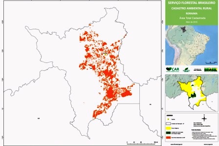
  • Area included in the digital mapping in the 1:50.000 scale in the territory

Mapping was carried out in the whole area the project covers, which corresponds to 7,180,000 hectares, including an update of map for the municipality of Paragominas according to the new Forest Code.

  • Number of priority area maps for forest restoration

Maps of priority areas for forest restoration in the 11 municipalities included in the project were produced.

  • Number of reports on governmental efforts towards land regularization in the state of Pará

Four reports were produced summarizing the following subjects:

  1.  performance of the Legal Land Programme in the Legal Amazon;
  2. pending land issues in the state of Pará;
  3. assessment of ITERPA information transparency; and
  4. efforts towards land regularization in the state of Pará in 2012 and 2013.

  • Annual deforestation rate in municipalities where the project activities were developed

Table 1 shows a substantial fall in deforestation in the 11 municipalities as a whole as of 2010 (baseline for the project). Except for the municipality of Itupiranga, all other municipalities recorded a decline in deforestation and presented annual deforestation rates below the 40 km2 ceiling established by the Ministry of Environment as one of the two conditions to be removed from the list of priority municipalities for efforts towards controlling and monitoring deforestation.Imazon-I-Table 1

  • Number of women working in coordination positions in the IMAZON:
    Nine women (50%) of a total of 18 positions.

SUSTAINABILITY OF RESULTS

In addition to the 44% fall in the deforestation rate in the group of municipalities, the project Social and Environmental Management of Pará Municipalities helped remove the municipalities of Dom Eliseu, Ulianópolis and Tailândia from the list of priority municipalities for efforts towards controlling and monitoring deforestation.

Being included on this list, in addition to giving the municipalities a negative image, implied a number of constraints for rural producers, including those of a credit nature.

Three other municipalities still on the list have already complied with at least one of the two requirements for exclusion: Moju and Rondon do Pará both present an annual deforestation rate below 40%, and 80% of the city of Itupiranga is already enrolled in the CAR.

The sustainability of these results depends on a number of factors, to which the project has made an important contribution, especially: continuously fulfilling local pacts to reduce deforestation in the municipalities, implementing procedures to establish accountability for environmental offenders, and permanently mobilizing all those interested in combating deforestation.

To access the effectiveness evaluation report of the "Socioenvironmental Management in Municipalities of Pará" project click here. This assessment was carried out by a team of independent consultants, under the coordination of the Deutsche Gesellschaft für Internationale Zusammenarbeit - GIZ. All opinions expressed are the sole responsibility of the authors, not necessarily reflecting the position of GIZ and BNDES.

Collection

In this area we offer some PDF files with the main publications generated by the project. Click the filename to start the download.